Trip Report: Lacamas Regional Park Day Hike
Hike Length: The trip described here is 5 miles long, but there are many hikes available (anything from a short walk to a full day of hiking)
Duration: 2-3 hours
Difficulty: Moderate
Distance From Portland: 20 miles (30 minutes)
When to go: Year-round! Spring is the best time to see the Camas Lily, summers are great for exploring the rocks around Pothole Falls, and winters are the best time to see the raging waterfalls.

Located in Camas, Washington, Lacamas Park is only half an hour away from downtown Portland! The 312-acre park is home to more than 12 miles of trails and is perfect for everything from a short afternoon walk to a full day of hiking. More than its size though, I LOVE the park’s landscape. There is nowhere else this close to the city where you can hike past roaring waterfalls, historic dams, sculpted canyons, deep forests, and rare wildflowers. Aside from Round Lake (which was dammed initially for milling and is maintained for recreational purposes) the entire park is untouched and natural, filled with towering trees and winding dirt and gravel paths.
There are multiple access points to Lacamas Park. The main parking lot is located on NE Everett Street in Camas, WA, just north of the intersection with NW Lake Road and next to Round Lake. Lacamas Regional Park is a maze of main trails, side trails, and many unofficial trails that wind around the park, and is open to pets and to bikers as well. I would recommend downloading a map before you go (or taking a photo of the map posted near the trailhead). Though there are many loops you can take through the park, in this post I will describe my favorite hike which is about 5 miles long and hits all the best features of the trail system.

The map, posted near the trail entrance. Note that this shows only the main trails; there are many trails in the park NOT included on this map.
Round Lake Upon leaving the parking lot, you will arrive on the shore of Round Lake. Round Lake is a popular place for fishing in the summer; near the trailhead you will find a display describing the geology of the lake and some of the water contamination history in the area. Pass by the bathrooms and the playground, set off to the right (counterclockwise) around the lake, and you will soon come to the Round Lake Dam.
 On the shores of Round Lake
Round Lake was initially dammed in 1883 to supply water to the La Camas Colony Paper Mill. The dam raised the level of the lake by 12 feet. During mill operations, water flowed over the dam and then through a 7,000-foot-long aqueduct (including a half-mile tunnel) to the paper mill. The trail leads right over the top of the dam! You’ll walk past some information signs, the hand-operated gate valves that control the lake level, and the spillway. This is the third dam to be built in this spot; the first was made entirely of wood. Also check out the fish screens to the left; these were built in 1940 to prevent fish from swimming over the dam and into the paper mill.

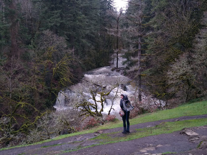
Pothole Falls During the summer when the water in Lacamas Creek is low, I’ll often scramble down the bank below the dam and then walk downstream along the shore of the creek to Pothole Falls. Pothole Falls rivals many of the waterfalls found in the nearby Columbia River Gorge. Because it is more remote and lesser known, you won’t have to navigate the crowds. The falls were sculpted over thousands of years by rushing water and tumbling rocks. If the water is low enough to walk downstream along the creek, you’ll be able to view many of the fall’s namesake potholes drilled into the bedrock.

If the water level is high or you want an easier route to Pothole Falls, you can continue across the dam and stay right until you hear the roar of the water. The trail opens on a ledge high above the falls. During summer weather, you’ll probably see people sunbathing on the rocks and swimming in the pool below the waterfall. You can access the pool yourself by scrambling down a steep use path to the water’s edge; if you’re brave, there are even a few cliff-jumping opportunities in the area!
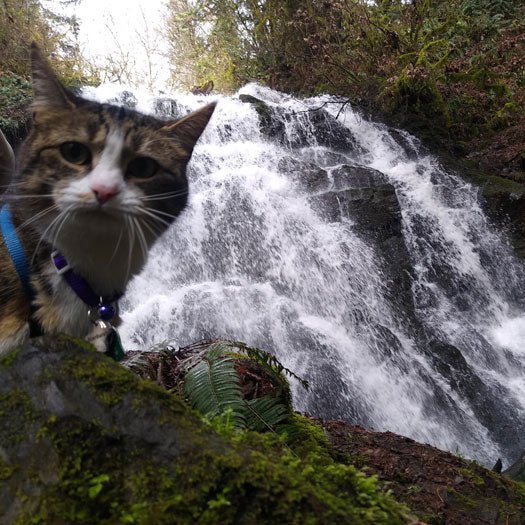
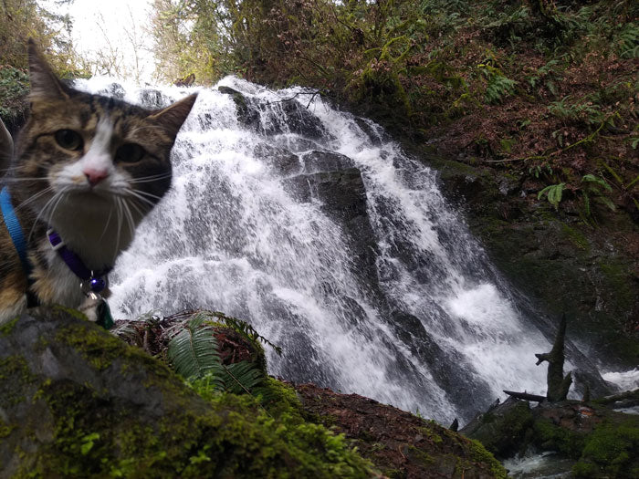
 View from above of Pothole Falls
Lower Falls Continue along the trail downstream below Pothole Falls, staying right at the next couple of intersections. This section of trail winds along the banks of Lacamas Creek through beautiful old-growth forests and across a small footbridge. Soon you’ll reach a bridge over Lacamas Creek just above Lower Falls. Although you will be staying on the north side of the creek, it is worth making a short side trip onto the bridge to view the water rushing below the wooden deck. Just a few steps further downstream you’ll reach Lower Falls. Though smaller than Pothole Falls, the water here is constricted by rock walls, creating a strong, spectacular flow- particularly at high water and during the winter.

Woodburn Falls Though the map at the trailhead only shows a path leading to Woodburn Falls from the north, there are actually a few different ways to get to the falls. The most direct is to walk about a tenth of a mile back upstream (the way you came) and then take an immediate right onto the unmarked trail. Walk uphill another tenth of a mile, then turn left. Soon, you will hear the splash of the falls ahead. This is my favorite area of Lacamas Park; Woodburn falls is smaller than both Pothole and Lower Falls, but feels even more secluded at the base of a ravine deep in the forest. It is a great place for a snack break or to rest a while and cool off during a hot summer day! A steep (and sometimes muddy) scramble will lead to the bank of the stream just below the falls, where you can balance on logs across to the other side.
The Camas Lily Fields The final highlight of Lacamas Park is the Camas Lily Fields. The city of Camas, (and Lacamas park), are named after this beautiful purple flower, which is endemic to the area and once covered the entire region. Camas Lilies were an important food source and tradeable commodity for the Blackfoot, Cree, and Nez Perce Tribes, as their roots are edible. The plant, which is actually a member of the asparagus family, blossoms in April and early May. Even outside of the flowering season, the Camas Lily Fields are a unique area to explore. Though the fields are only a few hundred feet above Round Lake, they feel as though they are a high alpine landscape. Shallow beds of dirt and moss cover bedrock outcroppings between the trees. Because this area is so fragile, and because this is the last field of Camas Lilies in the world, it is important not to leave the trail in this area.

To get to the Camas Lily Fields, follow the trail uphill and to the west, continuing straight at the 4-way intersection at the top of the hill. When you reach the wide gravel path, take a left and walk gradually downhill about a quarter mile to the smaller trail on the right turn. Follow this lesser-traveled trail, then take the first right uphill into the Camas Lily Fields. Whether you visit when the lilies are in bloom or later in the summer, the air here often smells sweet.

To Return to Your Car Once you have explored the Lily Fields, return to your car by exiting the fields to the north (at the top of the hill) and taking a left. Continue downhill following the trail until you reach Round Lake, then follow the path along the shore in a counterclockwise direction (keeping the water on your left) until the trail emerges on NE 35th Ave. Keep to the left, following the road, and soon you will see the parking lot up ahead.