
Trip Report: Cape Horn Trail - Washougal, WA
When: 12/09/2017
Location: Cape Horn Trail - Washougal, WA
Conditions: Rainy, snowy, and cold. Poor visibility.
Duration: 7.1 miles
Difficulty: Moderate
Kid Friendly: No
Pet Friendly: Yes
Usefull links: www.oregonhikers.org
 The Full Report:
Yet again I found myself in Washington discovering awesome hikes! I've recently been trying to hike at least once a week to stay active and get out of the house during the stresses of the holiday season, and Cape Horn seemed like the perfect hike to decompress.
This hike is only 45 minutes from my house in Clackamas and is located in Washougal, WA. In researching the hike, sites mentioned that Cape Horn offered expansive views of the Gorge and waterfalls galore, so I was stoked to get out and explore this hidden gem. I started the day late and left at 10:30am, arriving about an hour or so later to a moderate sprinkle of rain in the Cape Horn parking lot.
After dawning my rain gear and multiple layers, I set out for the trailhead about 100 feet from the lot on the east side of Salmon Falls road. It's important to note that the trail begins by forking in two directions, one in the direction of the "upper trail," the other the "lower trail." Remember that the hike is a loop, so you will end up covering both routes eventually. Keep in mind as well that if you're hiking from February 1st to July 15th, the lower section of the trail will be closed on account of Peregrine falcon breeding season.
I took the upper trail and started my ascent just as it began to lightly snow. Because of the elevation of Cape Horn, snow is common this time of year, but with a down jacket and waterproof shell, colder temperatures were manageable.
The hike is generally well marked with signage to keep you on trail even at smaller road crossings or parts of the trail that meanders through private property. That being said, while wooden guide signs are marked with the word "trail,' there is no indication of distance and you will have to refer to the larger map at the parking lot to get an idea of distances and landmarks according to the many viewpoints on the trail.
The Full Report:
Yet again I found myself in Washington discovering awesome hikes! I've recently been trying to hike at least once a week to stay active and get out of the house during the stresses of the holiday season, and Cape Horn seemed like the perfect hike to decompress.
This hike is only 45 minutes from my house in Clackamas and is located in Washougal, WA. In researching the hike, sites mentioned that Cape Horn offered expansive views of the Gorge and waterfalls galore, so I was stoked to get out and explore this hidden gem. I started the day late and left at 10:30am, arriving about an hour or so later to a moderate sprinkle of rain in the Cape Horn parking lot.
After dawning my rain gear and multiple layers, I set out for the trailhead about 100 feet from the lot on the east side of Salmon Falls road. It's important to note that the trail begins by forking in two directions, one in the direction of the "upper trail," the other the "lower trail." Remember that the hike is a loop, so you will end up covering both routes eventually. Keep in mind as well that if you're hiking from February 1st to July 15th, the lower section of the trail will be closed on account of Peregrine falcon breeding season.
I took the upper trail and started my ascent just as it began to lightly snow. Because of the elevation of Cape Horn, snow is common this time of year, but with a down jacket and waterproof shell, colder temperatures were manageable.
The hike is generally well marked with signage to keep you on trail even at smaller road crossings or parts of the trail that meanders through private property. That being said, while wooden guide signs are marked with the word "trail,' there is no indication of distance and you will have to refer to the larger map at the parking lot to get an idea of distances and landmarks according to the many viewpoints on the trail.
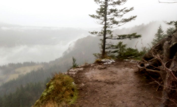 After about 30 minutes of hiking, I reached Pioneer Point, a gorgeous viewpoint about 1.2 miles into the trail. The Columbia River is crisp from this vantage and because you've already gained about 800 feet of elevation, you're high above the parking lot in view to the side. Because visibility wasn't amazing, much fog obscured my view, but on a clear day, Hamilton Mountain, Mist Falls, Multnomah Falls, and Beacon Rock are in plain view.
About a half a mile after this viewpoint, you will come across a road crossing where trail signs will direct you down a quarter mile driveway to connect with the next part of the trail. It restarts on the left side and after a bit more walking, you will hit Phoca Viewpoint that is marked by a large stone amphitheater with sweeping views of the Gorge in all its glory. I definitely recommend eating lunch or a snack in this area!
After about 30 minutes of hiking, I reached Pioneer Point, a gorgeous viewpoint about 1.2 miles into the trail. The Columbia River is crisp from this vantage and because you've already gained about 800 feet of elevation, you're high above the parking lot in view to the side. Because visibility wasn't amazing, much fog obscured my view, but on a clear day, Hamilton Mountain, Mist Falls, Multnomah Falls, and Beacon Rock are in plain view.
About a half a mile after this viewpoint, you will come across a road crossing where trail signs will direct you down a quarter mile driveway to connect with the next part of the trail. It restarts on the left side and after a bit more walking, you will hit Phoca Viewpoint that is marked by a large stone amphitheater with sweeping views of the Gorge in all its glory. I definitely recommend eating lunch or a snack in this area!
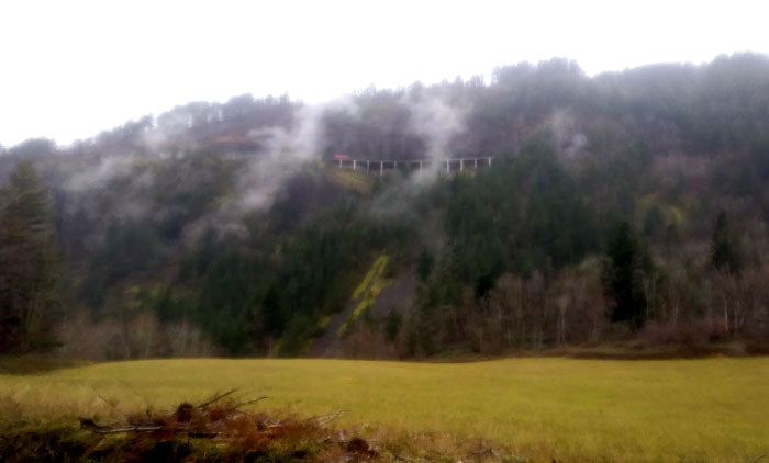
 From here the trail descends and can be somewhat steep at points. Because of the snow and rain, the next section of trail was muddy and a bit slick, so make sure you're pacing yourself on the downhill. Eventually, you will reach a small tunnel and the descent continues and is speckled with smaller viewpoints along the way that reveal a waterfall and more majestic views of the Gorge and Columbia.
After encountering more rugged terrain on the descent, you will happen upon Cigar Rock, a spire located on the edge of the river bank. As a side note, this is one of the coolest views I've experienced in the Gorge as it can be rare that trails ever direct you to such a low point near rocky shores of the Columbia. But the splendid and awe-inspiring views didn't stop there as after a bit more treading through loose rocks on the trail, a river crossing reveals Cape Horn falls. These falls are accessible a few feet off trail and boom with thundering crashes of water as they wallop the stream bed below and drain into the Columbia.
The rest of the trail is rugged, and you may be using your hands for stability as you continue your final approach to the private road at the end of the trail. After reaching a road, you will continue left for 1.3 miles to arrive at the original parking lot from which you started. I found that after the hike I felt accomplished and worn out, so this is a great hike for energetic pets or a solid workout for folks looking to cross train during winter. After reaching the parking lot and slinking back into my car, I headed back to Portland content and renewed.
From here the trail descends and can be somewhat steep at points. Because of the snow and rain, the next section of trail was muddy and a bit slick, so make sure you're pacing yourself on the downhill. Eventually, you will reach a small tunnel and the descent continues and is speckled with smaller viewpoints along the way that reveal a waterfall and more majestic views of the Gorge and Columbia.
After encountering more rugged terrain on the descent, you will happen upon Cigar Rock, a spire located on the edge of the river bank. As a side note, this is one of the coolest views I've experienced in the Gorge as it can be rare that trails ever direct you to such a low point near rocky shores of the Columbia. But the splendid and awe-inspiring views didn't stop there as after a bit more treading through loose rocks on the trail, a river crossing reveals Cape Horn falls. These falls are accessible a few feet off trail and boom with thundering crashes of water as they wallop the stream bed below and drain into the Columbia.
The rest of the trail is rugged, and you may be using your hands for stability as you continue your final approach to the private road at the end of the trail. After reaching a road, you will continue left for 1.3 miles to arrive at the original parking lot from which you started. I found that after the hike I felt accomplished and worn out, so this is a great hike for energetic pets or a solid workout for folks looking to cross train during winter. After reaching the parking lot and slinking back into my car, I headed back to Portland content and renewed.
The Full Report:
Yet again I found myself in Washington discovering awesome hikes! I've recently been trying to hike at least once a week to stay active and get out of the house during the stresses of the holiday season, and Cape Horn seemed like the perfect hike to decompress.
This hike is only 45 minutes from my house in Clackamas and is located in Washougal, WA. In researching the hike, sites mentioned that Cape Horn offered expansive views of the Gorge and waterfalls galore, so I was stoked to get out and explore this hidden gem. I started the day late and left at 10:30am, arriving about an hour or so later to a moderate sprinkle of rain in the Cape Horn parking lot.
After dawning my rain gear and multiple layers, I set out for the trailhead about 100 feet from the lot on the east side of Salmon Falls road. It's important to note that the trail begins by forking in two directions, one in the direction of the "upper trail," the other the "lower trail." Remember that the hike is a loop, so you will end up covering both routes eventually. Keep in mind as well that if you're hiking from February 1st to July 15th, the lower section of the trail will be closed on account of Peregrine falcon breeding season.
I took the upper trail and started my ascent just as it began to lightly snow. Because of the elevation of Cape Horn, snow is common this time of year, but with a down jacket and waterproof shell, colder temperatures were manageable.
The hike is generally well marked with signage to keep you on trail even at smaller road crossings or parts of the trail that meanders through private property. That being said, while wooden guide signs are marked with the word "trail,' there is no indication of distance and you will have to refer to the larger map at the parking lot to get an idea of distances and landmarks according to the many viewpoints on the trail.
After about 30 minutes of hiking, I reached Pioneer Point, a gorgeous viewpoint about 1.2 miles into the trail. The Columbia River is crisp from this vantage and because you've already gained about 800 feet of elevation, you're high above the parking lot in view to the side. Because visibility wasn't amazing, much fog obscured my view, but on a clear day, Hamilton Mountain, Mist Falls, Multnomah Falls, and Beacon Rock are in plain view.
About a half a mile after this viewpoint, you will come across a road crossing where trail signs will direct you down a quarter mile driveway to connect with the next part of the trail. It restarts on the left side and after a bit more walking, you will hit Phoca Viewpoint that is marked by a large stone amphitheater with sweeping views of the Gorge in all its glory. I definitely recommend eating lunch or a snack in this area!
From here the trail descends and can be somewhat steep at points. Because of the snow and rain, the next section of trail was muddy and a bit slick, so make sure you're pacing yourself on the downhill. Eventually, you will reach a small tunnel and the descent continues and is speckled with smaller viewpoints along the way that reveal a waterfall and more majestic views of the Gorge and Columbia.
After encountering more rugged terrain on the descent, you will happen upon Cigar Rock, a spire located on the edge of the river bank. As a side note, this is one of the coolest views I've experienced in the Gorge as it can be rare that trails ever direct you to such a low point near rocky shores of the Columbia. But the splendid and awe-inspiring views didn't stop there as after a bit more treading through loose rocks on the trail, a river crossing reveals Cape Horn falls. These falls are accessible a few feet off trail and boom with thundering crashes of water as they wallop the stream bed below and drain into the Columbia.
The rest of the trail is rugged, and you may be using your hands for stability as you continue your final approach to the private road at the end of the trail. After reaching a road, you will continue left for 1.3 miles to arrive at the original parking lot from which you started. I found that after the hike I felt accomplished and worn out, so this is a great hike for energetic pets or a solid workout for folks looking to cross train during winter. After reaching the parking lot and slinking back into my car, I headed back to Portland content and renewed.